Contact
Links
Kreisler-Game
ImageMap
Fuel
HTML-Include
ImageMap
Dial
CDP
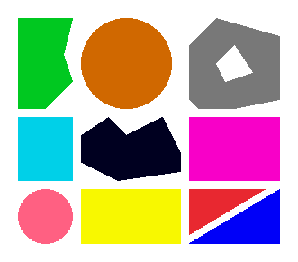
This is how the HTML code for the imagemap above looks like:
<IMG SRC="pics/ImageMapDemo.png" WIDTH="384" HEIGHT="291" USEMAP="#DEMONAME">
<MAP NAME=DEMONAME>
<AREA SHAPE=POLY COORDS="131,200,131,200,90,180,90,149,119,130,141,150,181,129,200,169,201,190" HREF="#blackpoly" ALT="">
<AREA SHAPE=RECT COORDS="210,130,311,201" HREF="#viorect" ALT="">
<AREA SHAPE=RECT COORDS="20,129,80,200" HREF="#bluerect" ALT="">
<AREA SHAPE=RECT COORDS="90,210,200,270" HREF="#yellowrect" ALT="">
<AREA SHAPE=CIRCLE COORDS="50,240,31" HREF="#pinkcirc" ALT="">
<AREA SHAPE=CIRCLE COORDS="140,70,51" HREF="#orangecirc" ALT="">
<AREA SHAPE=POLY COORDS="210,261,210,261,210,210,293,210" HREF="#redpoly" ALT="">
<AREA SHAPE=POLY COORDS="209,270,209,270,310,210,311,270" HREF="#bluepoly" ALT="">
<AREA SHAPE=POLY COORDS="220,120,220,120,210,111,210,48,241,20,309,40,310,110,262,120,240,70,260,50,281,80,249,92,261,120" HREF="#holepoly" ALT="">
<AREA SHAPE=POLY COORDS="50,121,50,121,19,122,19,19,80,19,70,58,80,90" HREF="#greenpoly" ALT="">
</MAP>
Click inside the map above to jump to one of the following lines.
You clicked on the black polygon. TOP
You clicked on violett rectangle. TOP
You clicked on the blue rectangle. TOP
You clicked on the yellow rectangle. TOP
You clicked on the pink circle. TOP
You clicked on the orange circle. TOP
You clicked on the red polygon. TOP
You clicked on the blue polygon. TOP
You clicked on the grey polygon with the hole. TOP
You clicked on the green polygon. TOP
EOF